"Basin modelling" is used during hydrocabron exploration to predict
HC-accumulations within a sedimentary basin.
Nonetheless, this tool is
very useful in solving scientific problems. Detailed background
information is available from
the DGSI page. I am using the
PetroMod 2D/3D software suite of IES GmbH, Jülich.
Example:
Modelling deep
basin gas accumulations in 3D -
an example from the
Alberta Deep Basin
C. Büker 1,2, A. Fröhlich 2, C. Zwach 3 & H.S. Poelchau 4
1 Institute of Geology and Geochemistry of Petroleum
and Coal, Aachen University of Technology, D-52056 Aachen, Germany
(bueker@lek.rwth-aachen.de)
2 Integrated
Exploration Systems (IES) GmbH, D-52428 Jülich, Germany
(carsten@ies.de)
3 Norsk Hydro AS, N-1320
Stabekk, Norway
4 Institute of
Chemistry and Dynamics of the Geosphere 4 (ICG-4), Forschungszentrum
Jülich, D-52425 Jülich, Germany
The Alberta Deep Basin (Fig. 1) contains an unconventional gas trap
where water saturated rocks overlie an almost gas
saturated,
thick sedimentary section of Lower Cretaceous age. The gas most probably
originated from the adjacent coal
bearing Upper Jurassic and
Lower Cretaceous sequence. The reservoir and source rock distribution in
the area is well
known due to extensive drilling, but the
processes involved in gas accumulation and preservation are still poorly
under-
stood. Three main theories in the literature attempt to
explain the present day occurrence of gas in the Alberta Deep Basin:
i) the on-going gas generation in source rocks at present day due to
very high heat flow (Maubeuge & Lerche, 1993),
ii) the desorption
of the gas from the coal source rocks due to uplift (Wyman, 1984),
and
iii) trapping due to permeability boundaries formed by
diagenesis (Masters, 1979).
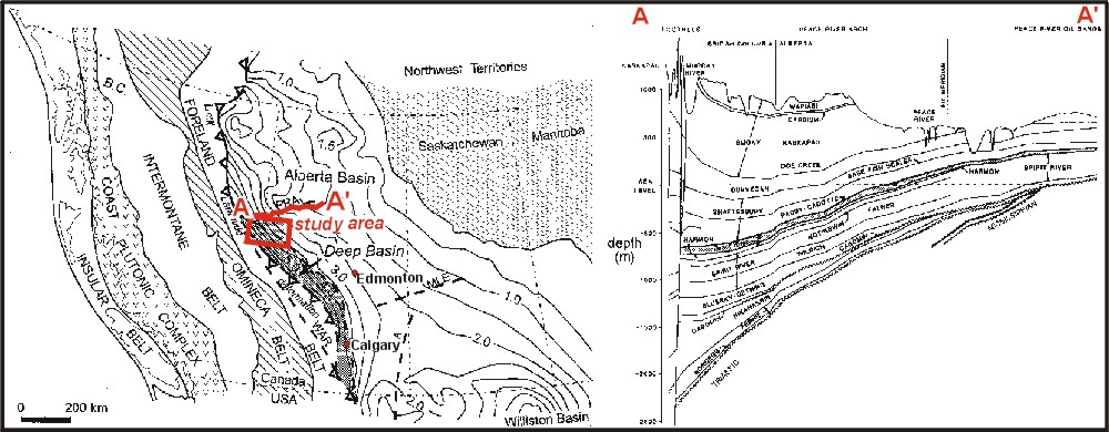
Figure 1
Left: Map of the
Western Canada Sedimentary Basin showing the isopachs of the sedimentary
fill (in kilometres), some
important tectonic elements of
the Alberta and the Williston Basin, and the five Cordilleran
tectonostratigraphic belts
of Western Canada. The study
area is located in the north-western part of the Alberta Deep
Basin.
Right: Structure of
the Alberta Deep Basin. Cretaceous formations (Cadomin and younger) are
gently dipping towards
the southwest .
To get a better understanding of how the gas accumulations formed and
why they still exist, 2D (Zwach, 1995) and a new
3D basin
modeling system were used. The regional erosion and heat flow history was
constrained using a detailed analysis
of acoustic velocities of shales
(Fig. 2), and vitrinite reflectance and fluid inclusion data,
respectively. The geometry of the
numerical models (Fig. 3; Tab.
1) was constructed using bore-hole data from a large database of some 1700
wells (Poelchau &
Zwach, 1993). For modeling the generation
of methane from coals, a specific kinetic data set (Krooss et al., 1993)
was used.
Some modelling results are shown in figures 4 and 5.
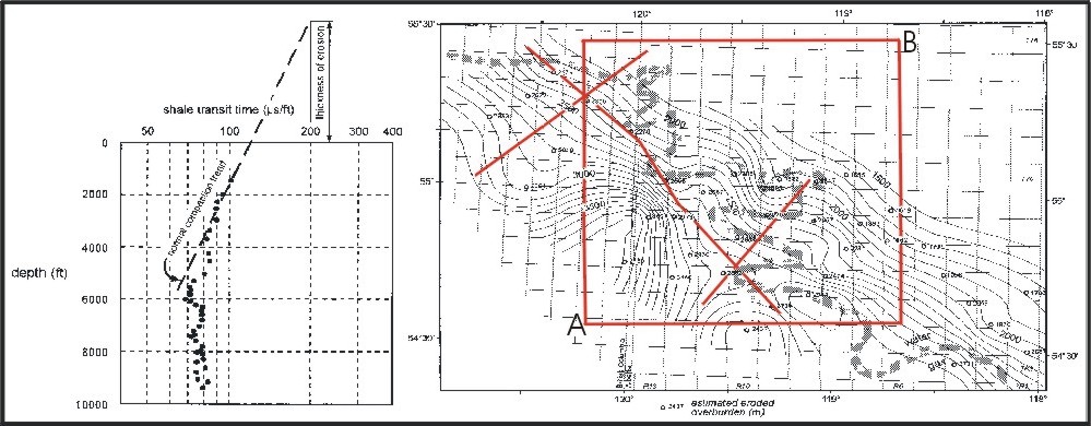
Figure 2
Left: Magara´s
sonic method of estimating thickness of eroded sediments (after Magara,
1986).
Right: Regional
estimated amount of eroded overburden after Poelchau & Zwach (1993).
Open circels indicate boreholes
on which Magara´s method (left)
was applied. Included are the locations of cross sections (red lines) and
the area (red
frame) for which 2D (Zwach, 1995) and 3D
basin modeling was carried out, respectively. Note the gas-water
contact
indicating that water saturated rocks in the
shallow northeastern part overly gas saturated rocks in the deeper
south-
western part of the basin.
Figure 3
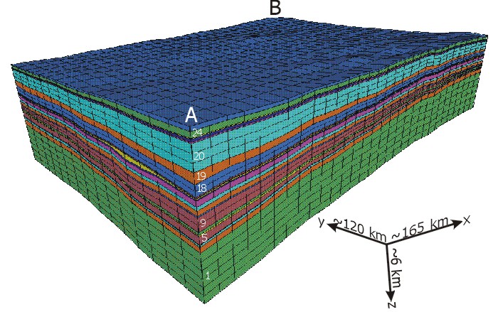
Finite-Element model of a part of the Alberta Deep Basin (see Fig. 2), consisting of 26 sedimentary layers (two are
eroded today; see Tab. 1 below). The model is formed by 30 x 15 x 43 grid cells (x, y and z-direction, respectively).
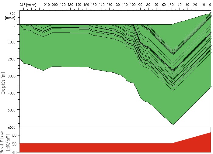
Figure 4
Burial history for the central grid cell
and heat flow history used in the Finite-Element model.
 |
|
|---|
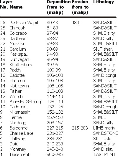
| Table 1 Basic input data for the Finite-Element model. Nikanassin, Bluesky-Gething and Falher contain the main source rocks and the Cadotte sandstone is the most important reservoir rock. |
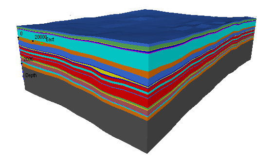
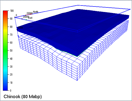
Figure 5 Modeled methane accumulation history. Overlay colors indicate the saturation of the pore space with methane (in percent).View is on top of Cadotte (layer 16 in Tab. 1). All layer on top of Cadotte are hidden. The uppermost, blue outlined layer is the today eroded Paskapo-Wapiti (layer 26 in Tab. 1), its upper limit is the earth surface. |
Conclusions
i) The Alberta Deep Basin was inverted during the Tertiary, and
significant amounts of Late Cretaceous and Early Tertiary
deposits were eroded.
ii) Methane generation in the Late Jurassic and Early Cretaceous source
rocks (coals) was mainly controlled by the depo-
sition of the later
eroded Late Cretaceous and Early Tertiary sequence.
iii) An on-going gas generation in the source rocks at present-day due to very high heat flow can be ruled out.
iv) The present-day gas saturation in the Early Cretaceous sequence
arises most likely from a combined effect of diagenetic
trapping and
desorption of gas from coals due to Tertiary uplift and erosion as pore
pressure and temperature decrease.
References
Krooss et al. (1993), Erdöl und Kohle - Erdgas -Petrochemie, 46 7/8:
271-276
Magara (1986), Collection Colloques et Séminaires, IFP,
44: 129-147
Masters (1979), AAPG Bulletin, 63/2: 152-181
Maubeuge
& Lerche (1993), Energy, Exploration & Exploitation, 11/3+4:
357-388
Poelchau & Zwach (1994), Reports Research Centre Jülich,
2882: 1-142 (B1); ISSN 0944-2952
Wyman (1984), AAPG Memoirs, 38:
173-187;
Zwach (1995), Reports Research Centre Jülich, 3082; ISSN
0944-2952.
Support of Canadian Hunter Exploration Ltd., Calgary, the German
Ministry of Research and Technology
(BMFT, project
No. ET6906A4) and the Research Center Jülich is is gratefully
acknowledged.